
Prof. Paul R. Baumann |

|
COPYRIGHT © 2022 Paul R. Baumann |
|
Between 1914 and 1960 aerial photography emerged from its infancy stage of individual endeavors into becoming an organized and sophisticated means of obtaining and interpreting aerial imagery toward specific goals. Much of this growth occurred during World War I, the Great Depression, World War II, and the Cold War. However, the term "remote sensing" had not yet become part of the vernacular. |
|
On December 17, 1903 Wilbur and Orville Wright piloted four successful air flights of a heavier-than-air machine that they built. They invented the first powered airplane. Their longest flight only lasted 57 seconds and the plane went slightly over 800 feet. The U.S. Army, seeing potential in the new technology, signed a contract with the Wright brothers in 1908 for the purchase of a machine that could travel with a passenger at a speed of 40 miles per hour. Within a short period of 11 years the development and application of the airplane had matured so fast that by the beginning of World War I in 1914 it had become the primary platform for aerial reconnaissance. Millions of aerial photographs were taken during the war. |
|
World War I Aerial Photography |
|
At the beginning of World War I the military on both sides of the conflict saw the value of using the airplane for reconnaissance work but did not fully appreciate the potential of aerial photography. Initially, an aerial observer, flying in a two-seater airplane with a pilot, did aerial reconnaissance by making sketch maps and verbally conveying conditions on the ground. The observer reported on enemy positions, supplies, and movements; however, some observers tended to exaggerate or misinterpret conditions. In some cases, their observations were based on looking at the wrong army. From above, identifying one soldier from another was not easy. On one occasion a German observer indicated that an English unit was running around in great disarray and the English should be attacked immediately since they were in a state of panic. It was later discovered that the English were playing soccer. As the next two pictures show, some of the platforms mentioned in the previous module were employed during the war. In the first picture a person is in a basket below a balloon. Balloons were easy taget to be shot down. The second picture shows Lieutenant Kirk Booth of the U.S. Signal Corps being lifted skyward by the giant Perkins man-carrying kites at Camp Devens, Ayer, Massachusetts. While the United States never used these kites during the war, the German and French armies put some to use on the front lines. The plane became the dominant aerial platform due to its stability and its ability to be controlled. |
 |
|
|
|
An English observer started using a camera to record enemy positions and found aerial photography easier and more accurate than sketching and observing. This aerial observer became an aerial photographer. Soon all of the nations involved in the conflict were using aerial photography. The maps used by both sides in the Battle of Neuve-Chappelle in 1915 were produced from aerial photographs. By the end of the war the Germans and the British were recording the entire front at least twice a day. |
|
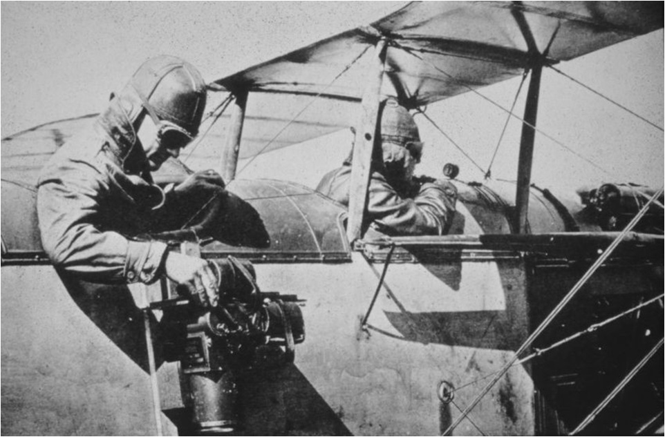
By far the greatest use of the airplane during World War I was to gather information about the enemy's positions and military resources. This information was obtained by aerial photography. Both sides of the conflict dedicated considerable resources to improving the technical capabilities of aerial cameras, processing aerial film quickly, learning how to interpret and measure features from aerial photographs, and disseminating the needed information from the photography to the commanders in the field. The first picture below shows an aerial photographer. Note that he is working using his bare hand; whereas, the pilot is wearing a heavy glove. It was generally quite cold flying several thousand feet in the air in an open cockpict but in order to operate the camera he needed to expose his hand to the cold. Members of the Air Service Photographic Section, 1st Army appear in the second picture. Once the film was brought back down to the ground it had to be processed. The men in the aprons are the individuals who developed the film. The men with the aerial cameras in front of them were the aerial photographers. There was a variety of cameras being used. |
 |
|
|
|
All countries possessed up-to-date records of their enemy's trench construction. England estimated that its reconnaissance planes took one-half million photographs during the war, and Germany calculated that if all of its aerial photographs were arranged side by side, they would cover the country six times. Below is a typical vertical aerial photograph showing trench construction. Also, below is an oblique aerial photograph showing the bombarded barracks at Ypres, viewed from 500 ft. Aerial photography was also used to assess damage due to bombing. |
 |
|
|
Trench Warfare at 2900 Feet in Altitude --- Bombarded Barracks at Ypres, Belgium |
|
Sherman M. Fairchild |

Sherman Mills Fairchild invented the first successful aerial camera and started the Fairchild Aerial Camera Corporation in New York in 1920. He developed a thriving business producing aerial cameras and making aerial surveys, which transformed the mapping industry. He was born April 7, 1896 in Oneonta, New York, to George W. Fairchild and Josephine M. Shernman. His father was a co-founder and the first chairman of IBM. As an only child Fairchild inherited his father's IBM stock, becoming IBM's largest individual stockholder until his death in 1971. Fairchild was a bright and naturally inquisitive child. When his parents gave him a camera for his 9th birthday, he did not take pictures with it; he took it apart to see how it functioned. In 1915 he entered Harvard University where, in his freshman year, he invented the flash camera. He also contracted tuberculosis. Under the advice of his physician, he moved to Arizona to recover in the drier climate and transferred his enrollment to the University of Arizona. There he learned about aerial photography. Arizona with its dry, clear sky environment was an ideal area to study aerial photography. He would later transfer to Columbia University. Near the end of World War I, he, as a restless inventor with personal wealth to develop his ideas, created an improved aerial camera that remained the standard into the 1950s. The camera featured a shutter inside the lens, thereby reducing significantly image distortion caused by slow shutter speeds that could not keep up with the movement of a plane. The elimination of this distortion greatly improved aerial photography and mapping. |
Fairchild also noticed that trying to obtain vertical photographs by holding a camera over the side of a plane and manually advancing the film was not a workable method for taking aerial photographs in a regular and systematic manner. In 1924 he founded the Fairchild Aviation Corporation and produced the first U.S. aircraft to include a fully enclosed cabin. With an enclosed plane he mounted his camera system inside the cabin with the lens positioned to view through an opening in the cabin floor. This improvement allowed for better vertical photographs to be taken relative to the movement of the aircraft. Also, by the cabin being heated, it was possible to fly missions under colder conditions. He included with his system an intervalometer, a device that activated the camera at a timed interval based on the speed of the plane. These changes allowed a series of vertical aerial photographs to be obtained systematically along an established flight line. The next two pictures show one of his first enclosed aircraft and the intervalometer. In front of the intervalometer is the viewfinder. |
 |
|
|
One of Fairchild's first enclosed planes and the intervalometer |
Fairchild believed that aerial photography had a great future especially by taking a series of overlapping photographs of the ground and creating a mosaic map that showed every feature of the land and every structure and road upon it. Although he had developed an excellent aerial camera - a camera that established the industry standard for 40 years – he was having a problem convincing people outside of the military about the potential use of such a camera. Thus, during the summer of 1922 he had one of his planes to fly over Manhattan Island and take a series of 100 overlapping photographs. The flight lasted one hour but it took six months trying to piece the photographs together so that streets and other surface features matched. A lot of the photographs had to be retaken when they were found to be out of scale. From this endeavor Fairchild discovered that he was a neophyte with respect to making accurate maps from aerial photographs. He spent several decades developing various devices to make it possible to mosaic photographs accurately.Also from this endeavor he successfully demonstrated how aerial photography could be used to inventory and survey ground conditions. A number of government agencies and business firms hired him to provide such information. For example, in 1922 East Haven, Connecticut wanted to reassess its real estate for a bond issue but it discovered a ground survey would take five years and cost $80,000. Fairchild did the job in 60 days and for a fee of $7,000. Fairchild also formed several companies to use aerial photography for business applications. The Laurentide Paper and Pulp Company, Quebec hired Fairchild to survey its Canadian forest lands. Within the first year of operation, 510 square miles of forest were mapped, demonstrating conclusively the value of aerial timber surveys over the ground methods. This resulted in the formation of the Fairchild Aerial Surveys, Ltd. in Canada. |
 |
|
Lower Manhatten Island (top) and Full resolution of the tip of the Island |
In 1957 Fairchild through his company, Fairchild Camera and Instrument, established the Fairchild Semiconductor Division. This division started when eight engineers approached Fairchild for funding to make transistors from silicon rather than germanium, the most common material for semiconductors at the time. Fairchild first marketed the transistor in 1958 and it became a huge success. A major purchaser of the new transistor was IBM. Fairchild's company became a leading force in Silicon Valley and spawned today's leading technology companies, such as Intel, Advanced Micro Devices, and National Semiconductor. With the new transistor, Fairchild's main company, Fairchild Camera and Instrument, was able to develop advanced aerial photo cameras, maybe the most sophisticated one being the Lunar Mapping Camera. This camera was a multiple camera system, which consisted of a terrain camera, a stellar camera and a laser altimeter, all integrated into one unit. It was designed to map the Moon. The following slides show the camera, its operation, and some examples of its Lunar photography. |
 |
 |
|
When the space station was in orbit around the Moon, the Lunar Mapping Camera was deployed from its storage location in the capsule bay. This provided a clear field of view for the stellar camera. The Lunar Mapping Camera only remained deployed while in use. When not in use it was retracted to its storage position in the bay, so as to avoid interference with other experiments. This photograph shows Apollo 15, Endeavour, and the Lunar Mapping Camera. The next two slides are two images of the Moon's surface. |
 |
|

In 1960 Time magazine put Sherman Fairchild's picture on its cover and had a feature article about his accomplishments. A few months before his death at the age of 74 in March, 1971, the Smithsonian Institution honored him on his fiftieth anniversary as a leader in the aviation industry. The list of inventions and technical improvements introduced by Fairchild during those years is long and varied. His aviation interests encompassed aerial photography, aerial mapping, aircraft design, semiconductors and airframe manufacturing processes. He also was one of the founders of American Airlines. |
Fairchild left a 200+ million dollar estate that went mainly to two charitable foundations: the Fairchild Foundation and the Sherman Fairchild Foundation. The Sherman Fairchild Foundation assets have grown to over 500 million in recent years. It promotes Fairchild's interest in aerial photography as well as other technological fields. |
|
1920s and 1930s |
In the twenty-year period between the end of World War I and the beginning of World War II, the field of aerial photography grew with respect to its technical development and non-military applications. With respect to technical development, World War I provided a laboratory for airphoto interpretation. When skillfully interpreted, an aerial photograph can provide a great amount of information about the physical and cultural landscape of an area at a given time. To help with the interpretation process certain methods and equipment were being developed resulting in the new field of photogrammetry, which is the science and art of obtaining reliable measurements from aerial photographs and satellite images. |
 |
|
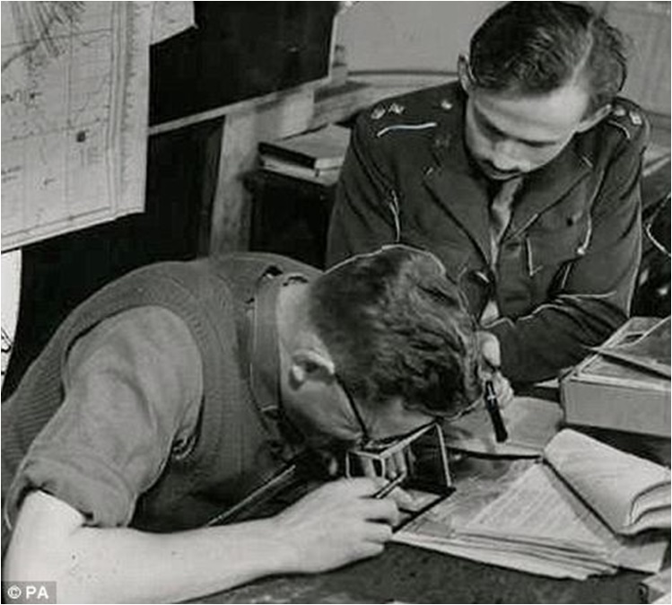
Two airphoto interpreters analyzing an enlarged aerial photograph. |
One of the major technical accomplishments during this period related to geometric distortion in vertical photographs known as position displacement. Features directly below the center of the camera lens will have only their tops visible, while all other features will appear to lean away from the center showing portions of their tops and sides. The farther away from the center the more the distortion will occur, resulting in positional errors. Also tall features such as tall buildings will produce greater distortion than small features s adding to the error. To partially address this error issue, vertical photos taken along a flight line generally have a forward overlap of 60% to 70%. In other words, the current photo captures a large portion of the previous photo in the flight line. In addition to forward overlap, sidelap occurs between adjacent flight lines. The amount of sidelap varies between 25% and 40%. The overlapping process reduces the chance of missing ground areas. Also, it produces stereopairs of airphotos, which permit interpreters to view ground features in 3D with the use of a stereoscope. |
 |
|
Diagram illustrating forward overlap and side overlap |
 |
|
An airphoto interpreter using a stereoscope. |
However, the greatest use of overlapping photos is to create a mosaic of the area being inventoried. Most aerial photographs are taken to produce mosaics of areas larger than a single photo can cover. Before the digital era a mosaic was developed by tacking adjacent photos on a wall and interlacing the lapped areas on the photos. It was necessary to align the same features, known as control points, on each photograph, a tedious task that involves as much art as science. Today, non-digital photos are scanned and their grey or color tones are numerically recorded based on the data points per inch. Software exists to seam together these photos to form a mosaic. |
 |
|
Mosaic Mapping at the U.S. School of Aerial Photography Langley Field, Virginia. |
In addition to the new technical developments occurring in aerial photography, interest in the non-military uses of aerial photography also increased during the 1920s and 1930s. Aerial photography had been taken for more than two-thirds of continental United States, most of which was taken in the latter half of the 1930s. Three federal agencies, namely the Soil Conservation Service, Agricultural Adjustment Administration, and the Forest Service, accounted for most of the work in aerial photography. Other agencies involved in aerial photography work included the U.S. Geological Survey (USGS), the Tennessee Valley Authority, the Coast and Geodetic Survey, and the Army Air Corps.
|
One non-military application of aerial photography dealt with the USGS and its task to map the entire country's topographic land surface. In the late 1880s USGS introduced the 15-Minute Quadrangle series. The purpose for developing this series was to provide a detailed topographic map coverage of the country at the same scale. The term "Quadrangle" was used to describe the four sides of the maps as being 15-minutes of latitude and longitude in length. These maps were also called the 62,500 series. The number 62,500 referred to the fractional scale used on the map. To make these maps it was necessary to survey the topography and create contour lines to illustrate the topography. Both the surveying and map making were labor intense processes. A large number of these maps were produced but they did not cover the entire United States. Today, Alaska is the only area for which 15-Minute maps are still being produced.
|
The 15-Minute map series was gradually replaced by the 7.5-Minute Quadrangle series, also referred to as 24,000 series. Maps in this series have been based on aerial photography and photogrammetry rather than land surveying. Much of the photography taken in the late 1930s was used throughout the 1940s to create this new map series. A large number of maps in the series were produced during this time period due to World War II. The series continues today based on currrent aerial photography and satellite imagery.
|
 |
The map on the left is the Oneonta NY 15-minute quadrangle. The map on the right is the 7.5-minute
quadrangle. Because of the detailed information provided by the 7.5-minute series, it would take four 7.5-minute maps to cover the same area
as the 15-minute map. |
Other events that occurred during the 1920s -1930 included: |
1920's - First books on aerial photo interpretation were published. Reeves' Aerial Photographs, Characteristics and Military Applications was published in 1927 followed by Winchester's and Wills' Aerial Photography, a Comprehensive Survey of Its Practice and Development and Pendleton's Map Compilation from Aerial Photographs in 1928. McKinley's Applied Aerial Photography became available in 1929. |
1924 - Mannes and Godousky patent their research on developing multi-layer color film. Their work led to Eastman Kodak producing Kodachrome in 1935. Color film was not used much for aerial photography until after World War II. Film speeds were too slow; camera lenses designed to correct for color were not readily available; atmospheric haze problems existed; and film processing was not consistent. |
1934 - Twelve people met in Washington, D.C. and from this meeting The American Society of Photogrammetry was founded. The Society's journal, Photogrammetric Engineering, was established at the same time. Today, the Society is known as The American Society of Photogrammetry and Remote Sensing and its journal has been renamed Photogrammetric Engineering and Remote Sensing. |
|
World War II |
|
World War II brought about tremendous growth and recognition to the field of aerial photography that continues to this day. In 1938, the chief of the German General Staff, General Werner von Fritsch, stated, "The nation with the best photoreconnaissance will win the war." By 1940, Germany led the world in photoreconnaissance. However, after von Fritsch's death the quality of German photointelligence declined. When the United States entered the War in 1941, it basically had no experience in military photointerpretation. By the end of the War, it had the best photointerpretation capacity of any nation in the world. In 1945, Admiral J. F. Turner, Commander of American Amphibious Forces in the Pacific, stated that, "Photographic reconnaissance has been our main source of intelligence in the Pacific. Its importance cannot be overemphasized." |
|
A review of the numerous uses of aerial photoreconnaissance and interpretation during World War II cannot be adequately covered in this instructional module. Thus, just one example will be provided. Peenemunde, the German experimental station for rocket and jet plane development, was located on the Baltic Coast, initially too far for the Allies' reconnaissance planes and bombers to reach. In 1937 Wernher von Braun and his rocket team were moved to Peenemunde. It was here that after six years of hard work von Braun and his team developed the A-4. On October 3, 1942 the A-4 was successfully launched reaching an altitude of sixty miles. It was the world's first launch of a ballistic missile and the first rocket ever to go into the fringes of space. In 1943 the A-4 was ordered into production and renamed the V-2. Shortly thereafter, V-2 rockets were launched against England. |
 |
Photo (left) taken June 23, 1943 of the V-2 test lunch site at Peenemunde. Photo (right) taken after bombing raid. |
|
In late 1942 the British Secret Intelligence Service was informed about a new rocket being developed at Peenemunde. An aerial photoreconnaissance plane was sent on June 23, 1943 and obtained the first photo of the 36 foot-long V-2 rocket. This aerial photo shows Test Stand VII at the German Testing Center with a V-2 rocket on its trailer inside of the test firing area. It also shows possible anti-aircraft gun positions on top of an adjacent building (red arrows). On August 17 and 18, 1943 the British sent its bombers to Peenemunde and rather than bombing the facility in general, precise targets were selected based on the excellent aerial photography previously obtained. The British lost 215 aircrew and 40 bombers in the operation. After the bombing a second aerial photoreconnaissance plane was sent to gain photography for assessing the amount of damage. |
|
Cold War |
|
After World War II and through the 1950s, the Cold War with the Soviet Union created a need for the United States to know about the military strength of the Soviet Union, especially with respect to the number of long range bombers and intercontinental ballistic missiles (ICBMs) that it possessed. Reconnaissance planes were being sent across the borders into the Soviet Union and its allied nations. However, these planes could only penetrate the edges of the country and the information needed was in the middle of the Soviet Union's large land mass. Over 200 of these planes and their crews never returned. A new plane was required. |
President Dwight Eisenhower was under pressure from the military-industrial complex in the United States to address the supposed large bomber and ICBM advantage that the Soviet Union had over the U.S. and the verbal threats being made by the Soviet leadership. Eisenhower put forth to the Soviet Union his Open Skies plan, which would have allowed aircraft from both countries to openly overfly each other's territory. The Soviet Union flatly rejected the plan. |
Thus, in 1954 Eisenhower had the CIA and the U.S. Air Force negotiate an arrangement with Lockheed to create, under the code-name AQUATONE, a special reconnaissance plane. This decision led to the development of the secret Lockheed Skunk Works in Burbank, CA where Kelly Johnson and his engineers created within a few months the U-2. Eisenhower realized that to fly such a plane over the territory of another nation was in violation of the other nation's sovereignty and could result in military reprisal. |
 |
|
U-2 gliding in air |
|
It was not easy to fly the U-2. It flew at 70,000 feet, about 25,000 feet higher than any other plane could fly at the time. At 70,000 feet the thin air can create a burnout condition where the engine stops and cannot be started. On one occasion a burnout occurred over Tennessee and the pilot glided his plane back to its home air base in New Mexico. The U-2 is designed like a large glider. |
|
The plane was stripped of its backup systems to keep its weight down in order to fly at such high altitudes. The camera system created an unusual problem for the plane. When loaded with film the camera system placed too much weight on the one side of the plane and not enough weight on the other side where the take-up spool was located. This situation formed an imbalance in the plane. Thus, a second camera was incorporated with its film roll on the other side of the plane. Each camera was designed to take every other photograph and in the process kept the plane balanced. The next slide illustrates how large the camera system was and the two rolls of film. The following slide shows the loading of the camera system into the plane. Note how the camera system was being hoisted into the plane. |
 |
|
Camera system being loaded into a U-2 |
 |
|
This is one of the first U-2s |
|
Note the small wheels under its wings of the plane. These wheels fall off the plane on takeoff in order to reduce its weight in flight. The next series of slides show how the plane was landed and how the wheels were reinstalled. The cost to build and maintain the plane and the challenges to fly it indicate how important aerial photography was during the Cold War. |
 |
|
A U-2 landing |
|
When the plane lands, a special guide car races behind it at 140 mph to help the pilot with the landing. Once the plane has landed and stopped it is tipped with one wing touching the ground. Airmen pull down the opposite wing to allow the wheel to be reattached to the other wing. This is one example of how the U-2 was stripped in order to reduce its weight, and thereby, be able to fly at high altitude. |
The first over-flight of the Soviet Union by a U-2 occurred on July 4, 1956. It took off from West Germany and flew over Poland, Belorussia, Moscow, Leningrad, and the Soviet Baltic states. It exposed 3,600 feet of film per mission using two high-resolution cameras. One camera had a long focal length allowing it to spot items that were two to three feet across. For five years the U-2's cameras took photos of ICBM testing sites and air bases within the Soviet Union. Each time the Soviet Union protested but could not shoot down the plane. U-2 flights were also made over other nations. The aerial photography from the plane proved that no bomber or missile gap existed between the United States and the Soviet Union as was previously suspected. |
 |
|
The is Engels Air Base, Russia. The image was acquired on the first U-2 flight and it is known as the "million-dollar" picture. It showed that no bomber gap existed between the U.S. and the Soviets Union. |
The next image, taken on a 1957 U-2 flight, shows the R-7 missile launch pad at the Tyuratum missile test center, later renamed the Baikonur cosmodrome. Baikonur is Russia's space port located in Kazakhstan. It has an interesting history. The Soviet Union's first intercontinental ballistic missile was launched here in August 1957. It travelled over 3700 miles and reached the Kamchatka peninsula. Six weeks later the World's first artificial satellite, Sputnik, was placed into orbit from this pad. In 1961, the first cosmonaut, Yuri Gagarin, began his space journey from this same launch pad. Until recently, the International Space Station was supplied by unmanned spaceflights from Baikonur. Manned spaceflights, with American astronauts, also flew from this space port to the station. |
In 1961 the Soviet Union announced to the World for the first time the location and the name of its secret launch site. However, it provided a false location by naming it after a small town 200 miles away from the actual location. Based on the 1957 U-2 image, the United States had already known of the precise location and named it more accurately Tyuratam after a railroad station 13 miles away. There are two slides showing the image. The left slide encompasses the entire pad site. The right slide is at 50 percent resolution and looks down on the pad. |
 |
|
Baikonur Cosmodrome |
On May 1,1960, using a cluster of 14 SA-2 missiles, the Soviet Union shot down a U-2 over its territory. The plane's pilot, Francis Gary Powers, survived. The Soviets staged a highly publicized trial to embarrass the United States.The United States agreed never to fly a reconnaissance plane across the Soviet Union again. This agreement included Communist China and Eastern Europe. These countries became known as the "denied areas." |
Based on the information gained from the U-2 flights over the Soviet Union, Eisenhower, an ex-military man, warned the nation before leaving the presidency about the influence of the military-industrial complex and its role in shaping U.S. policy. It was the pressure from this complex that led to the development of the U-2 and the possible conflict with the Soviet Union. |
Anticipating that the Soviet Union would eventually find a way to bring down a U-2, the Central Intelligence Agency (CIA) created a program it called OXCART that funded the development and production of a new plane, the A-12. The plane was a reconnaissance aircraft built again by Lockheed's famed Skunk Works and based on the designs of Clarence "Kelly"Johnson. Preliminary design work on the aircraft was started in late 1957. It was initially referred to as the "Archangel", after the U-2 program, which had been known as "Angel". Thirteen A-12s were produced between 1962 and 1964, and they were in operation from 1963 until 1968. The plane was designed to fly over Mach 3; to reach an altitude of 90,000 feet; and to be stealthy. No such plane had ever been built before to meet these specifications. It was the precursor to the famous SR-71 Blackbird reconnaissance aircraft. Officially a secret for over forty years, the CIA began declassifying the A-12 program in 2007. |
 |
|
A-12 Archangel |
To build the plane was quite problematic. For reasons of weight, the interior of the plane had to be constructed with almost no thermal insulation, converting the cockpit into a true oven. Temperatures in the cockpit ranged between 400 and 450 degrees Fahrenheit. As a result, the pilot had to use an astronaut-like suit with its own refrigeration system. Pilots would typically lose up to 5 pounds in a four hour flight. Officially secret for over forty years, the CIA began declassifying A-12 program details for release in 2007. |
The aircraft skin had to be made out of a titanium alloy, in order to resist 550 degrees Fahrenheit temperatures while flying at top speed. The United States had very little titanium but the Soviet Union had large deposits of the ore. It was quite a process to get the ore from the Soviet Union without it knowing how it was going to be used. Third-party countries had to be involved in obtaining the titanium. The aircraft manufacturing process was an absolute nightmare. All machinery broke trying to work the titanium and new tooling parts had to be designed and created from scratch. As a result, each plane had to be hand-crafted. |
 |
|
Moving the huge A-12 spy plane from California to Area 51, highly classified Air force Base
in Nevada, while keeping it a secret was a challenge. The plane needed to be tested in a large area, empty of any human settlements. |
 |
|
Slowing the plane down to be refueled in mid-air was also a challenge. |
Testing the plane at Area 51 required some interesting "cat and mouse" work. In order to hide the plane from the Soviets, a schedule had to be prepared as to when the plane could be outside its hangar. A daily roster was maintained as to when Soviet satellites would be coming across the area. |
As part of the radar test to determine the plane's level of stealthiness, the plane was frequently hoisted atop a tall pole. See the next two slides. The first slide shows the A-12 being mounted on the pole. It was quite a process to take the plane up and down the pole and move it quickly into a hangar in order to avoid the Soviet satellites. The second slide shows the plane up-side-down on the pole. Note the shadow and the size difference between the Jeep and the A-12. It was discovered years later that the Soviets knew about the plane through one of their infrared satellites. In a hot desert environment the shadow of the plane on the desert floor was cooler than surrounding surfaces; thereby, creating a silhouette detectable via infrared imagery. All of this effort was done to develop a plane that could obtain aerial photographic information. |
 |
|
Inverted A-12 being prepared for radar testing in Area 51 |
The fleet made a total of 2,850 test flights at Area 51. In 1967 most of the fleet was deployed to Asia, to Kadena Air Base, Okinawa where the A-12 was used in Operation Black Shield. The planes flew over North Vietnam, photographing Surface-to Air missile (SAM) sites. They were flying at 80,000 feet and at Mach 3.1. They also flew over North Korea and parts of China. The cancellation of the A-12 program was announced on 28 December 1966, due to budget concerns, and because of the forthcoming Air Force’s SR-71. It continued to operate until 1968 and remained a secret until 1981. |
 |
|
Fleet of A-12s at Area 51 |
According to the CIA Museum, the "A-12 represents a pioneering achievement in aeronautical engineering and, to this day, holds records for speed and altitude (Mach 3.29 at 90,000 feet) for an air-breathing piloted jet aircraft." Mach 3.29 is 2207 miles per hour at 90,000 feet. |
 |
|
SR-71 Blackbird |
The first SR-71 to enter service was delivered in 1966. Thirty-two planes were built. They were longer and heavier than the A-12, with a longer fuselage to hold more fuel, two seats in the cockpit, and reshaped chines. It flew at over Mach 3 but slightly slower than the A-12. There were tandem cockpits, with the pilot in the forward cockpit and the reconnaissance systems officer operating the surveillance systems and equipment from the rear cockpit, and directing navigation on the mission flight path. Reconnaissance equipment included signals intelligence sensors, a side-looking airborne radar, and various photo cameras. It also included a Fairchild tracking camera of modest resolution and an infrared camera, both of which ran during the entire mission to document where the aircraft flew and answer any post-flight political charges of overflight. The camera systems were located in the wing chines or in the interchangeable nose of the aircraft. It was also designed to minimize its radar cross-section, an early attempt at stealth design.Finished aircraft were painted a dark blue, almost black, to increase the emission of internal heat and to act as camouflage against the night sky. The dark color led to the aircraft's nickname "Blackbird". |
 |
|
Rear Cockpit: Reconnaissance Systems |
As part of the OXCART program Lockheed developed a supersonic reconnaissance drone given the code name D-21.It was designed to be launched from the back of an M-21 carrier aircraft, a variant of the Lockheed A-12 aircraft. Its maximum speed was in excess of Mach 3.3 (2,200 miles per hour) at an operational altitude of 90,000 feet. It was designed for reconnaissance deep into enemy airspace. It carried a single high-resolution photographic camera over a designated path. Once a mission was completed the camera module was released into the air for retrieval and the drone self-destructed. Several test flights were made, followed by four unsuccessful operational flights over the People's Republic of China, before the program was canceled. |
 |
|
D-21 Blackbird drone sidekick |
SR-71 never became a major reconnaissance platform since no military conflicts occurred during its tour of duty and satellite imagery had become available. Due to politics and budget concerns, it was retired in 1990. However, the USAF still kept a few SR-71s in operation up until 1998, with its final flight occurring in October 1999. |
Lockheed Martin has proposed and is supposedly developing an SR-72, known as the "Son of Blackbird." It is a hypersonic unmanned aerial vehicle designed for intelligence, surveillance and reconnaissance. It will fly at Mach 6 (4000 mph.). Lockheed expects that an SR-72 test vehicle could fly by 2025. Since satellites and drones already provide very high resolution imagery, the need for this new plane is questionable. |
|
Final Comments |
|
1. During the period from 1914 to 1960, the plane became the primary platform for acquiring aerial photographs. The balloon, kite, rocket, and even the pigeon continued to be used as platforms but only for minor events. |
|
2. Vertical photography became the primary type of aerial photography. Oblique photography, generally associated with the aerial photographs taken in the 1800s, was used less during this time period. |
|
3. Aerial photography came to be viewed as a major source of information. Vertical photos allowed for accurate measurements and better interpretations of conditions on the land surface, and thereby, provided vital information. The fields of photogrammentry and airphoto interpretation were established. |
|
4. The military became heavily involved in aerial photography and spent huge sums of money on aerial reconnaissance planes and techniques. |
|
5. Aerial photography was used to inventory and monitor over ninety percent of the land in the United States. |
|


